David Link

Tour the regions east and south of San Francisco on a Bay Area motorcycle ride with REVER. San Francisco may get most of the attention, but there is a lot more to see on Bay Area motorcycle rides outside of The City By The Bay. Oakland, San Leandro, Hayward, Santa Clara and San Jose all have excellent Bay Area motorcycle roads that will help you escape the city when you need a break from the crowds. All you need to do is download the REVER App, pick a route below and fire up your bike!
Nothing quite matches the thrill of the open road, and the REVER App helps you clock mile after epic mile of the best Bay Area motorcycle rides. You'll uncover top routes vetted by industry professionals, unique challenges designed to push your limits and live trip tracking all for free. It only takes moments to download the app, and you can hit Bay Area motorcycle roads right away. But for the best touring experience, you're going to need REVER Pro. Just a few bucks a month unlocks premium features like turn by turn and voice navigation, weather radar and alerts, LiveRIDE real time location tracking and so much more. It's the best way to see all the Bay Area has to offer.
Oakland and the surrounding towns of Berkeley, Hayward and San Leandro are generally sunnier and warmer than San Francisco as they aren't subject to the fog and chilly wind that is common closer to the ocean. You may see fog close to the bay in the morning, but it burns off pretty quickly as the sun rises. The summers in Oakland are warm and rain is fairly rare, so the riding conditions are near perfect. San Jose receives even less rainfall than Oakland, so you can tour without worry of dark skies ruining the day. You will experience regular rainfall in the winter, so pack the rain gear before you go. However, the weather shouldn't deter you from excellent rides in the area. The mountains east of the Bay Area transform quickly into desert terrain, so don't forget to stay hydrated with a motorcycle hydration system. If a higher elevation ride is on your list, don't forget to layer up and bring a reliable cold weather riding jacket.
The Bay Area provides rich attractions outside of San Francisco, and you can start your sightseeing in Oakland. First, you'll want to walk along the waterfront and grab a bite to eat at Jack London Square. This new area is part of the dedicated effort to revitalize the Oakland area, and you'll definitely want to make a stop to see the transformation. If you're interested in American history, the USS Potomac moored right next to Jack London Square offers a unique way to cruise the bay. This restored ship was once known as “The Floating White House” for President FDR. From there, head over to the Oakland Coliseum to catch an Athletics game. While this certainly isn't the fanciest stadium in MLB, the constant chants and banging drums from dedicated fans more than make up for it.
South from Oakland and its neighboring cities is San Jose, and it is actually beats out San Francisco as the largest city in Northern California. Silicon Valley offers its share of attractions both in the city and the surrounding mountains. San Jose is about four hours from Yosemite National Park, and it is well worth your time to take a break from motorcycle rides Bay area and head over to this majestic park. Or stay in town and tour the haunted halls of the Winchester Mystery House. Sarah Winchester was the heiress to the Winchester Repeating Arms fortune, and in the late 1800s, she built a maze-like mansion with over 160 rooms in San Jose. San Jose is also host to the Sharks NHL team if you want to catch a hockey game after a ride. Finally, if you want to do your own exploring on motorcycle routes Bay Area, there are hundreds of miles of coastal highways to the north and south that will take your breath away.
Few places in the world stun riders more than the ride from Monterey to Big Sur on the Pacific Coast Highway. You could easily call this route the best road trip in America, and few would argue. This section of California Route 1, also known as the Pacific Coast Highway, hugs the cliffs of the Big Sur area. Here the Santa Lucia Mountains emerge dramatically from the sea, and much of this rugged coastline is dotted with rock formations that jut out of the ocean. You'll will have to ride a fair bit south from San Jose, CA, but the trip is 100% worth it.
There are a couple other things to know before you go. This route is extremely popular, especially in the summer. Much of the ride consists of a winding two lane road, and it can get pretty bogged down by tourists. You can opt to hit this route in the winter during the off-season, and you'll experience far less traffic, but the temperatures will be cooler. One last note, this section of highway is subject to landslides. In 2017, a massive landslide closed a section of the Pacific Coast Highway for over a year. No problem, you can just go around, right? There is actually only one road that leads inland from the Big Sur area, so when you take the PCH, it's pretty much your only option. The moral of the story is check for road closures before you head out!
We'll start this route in Carmel-by-the-Sea, CA, just south of Monterey. You'll find two world-famous attractions in this area, Pebble Beach Golf Course and the Monterey Bay Aquarium. As you ride south out of Monterey on the 1, the road narrows into a two lane highway and the epic sights begin immediately. First, you'll pass by Point Lobos known for its sea lion viewing. Cruise the rocky Pacific coast, and keep an eye out for viewpoints like China Lookout that offer a chance to pull off and get a closer look at the ocean. Garrapata State Park Vista Point is just south of China Lookout, and there will be plenty more pull off opportunities to come. You'll cross over the Granite Canyon Bridge and Garrapata Creek Bridge on the way to Notleys Landing. The 1 is famous for its iconic bridges, and one of the most popular is next up in the Rocky Creek Bridge. This concrete arch bridge is sometimes mistaken for the world-famous Bixby Creek Bridge, but it is beautiful in its own right. Hang tight on pulling off for another mile as the Bixby Bridge is ahead.
Chances are even if you've never been to California before, you've seen the Bixby Creek Bridge. This epic concrete arch bridge spans 360 feet over Bixby Creek right next to the ocean. It was completed in 1932, and it is still one of the tallest single-span arch bridges in the world. There is a viewpoint right before you ride over the bridge, but it can only accommodate a few cars at a time. Still, you should have an easier time squeezing in a bike if you want to stop and marvel at the bridge. If you have an ADV setup, you can opt to take the Old Coast Road up to a higher viewpoint, and you'll encounter less traffic here as this is a rough dirt road. Once you've had your fill of the Bixby Bridge, keep winding along the cliffs past more viewpoints and over the Little Sur River. After the Point Sur Lighthouse, you'll ride through Andrew Molera State Park that features several hiking trails next to the coastline. This area is where you'll find most of the lodging for Big Sur as well if you're staying the night.
Once you pass the Big Sur Lodge and Campground, there is a short detour out to the ocean that you don't want to miss. Ride out to Pfeiffer Beach on a narrow, sometimes one lane road and park to see the rock formations out on the beach. You may have to wait a bit if the parking area is at capacity. The highlight here is a large rock out in the ocean with a natural arch carved through the middle. You'll be surprised at just how mesmerizing it is to watch wave after wave crash through the arch. Back on the PCH, the next section heads into the forest, and this is where you'll find the few restaurant options in the Big Sur area. Nepenthe is the most popular place to eat, and this unique restaurant perched on the cliff is definitely worth the visit. You will likely encounter long wait times if you're riding through in the summer, and there are no reservations, so keep that in mind. The Big Sur Smokehouse is a good backup plan if the Nepenthe wait times are insane.
Our REVER route ends here in Big Sur, but you'll want to ride a little farther down the Pacific Coast Highway to Julia Pfeiffer Burns State Park. The star attraction here is McWay Falls, and it is only a very short hike near the road to see the falls. This waterfall flows 80 feet down from the cliffs right onto a hidden sand beach or directly into the ocean if it is at high tide. Unfortunately, you can't hike down to the beach itself, but even seeing the waterfall from the viewpoint is a can't-miss stop. There are many more miles of rugged coastline if you keep riding south, but not much in the way of services or food until you get to Cambria, CA. You can also turn around and ride back up north to complete the ride, as it's almost impossible to get enough of this epic route.
<a href="https://rever.app.link/JTCXKGTFtH" class="btn article-preview__btn w-button">View In App</a>


Ride out of Silicon Valley into the Diablo Range east of the Bay Area on this five hour plus trek. This route is paved, but portions of it contain single-lane roads and rough pavement, so it's best to have an ADV setup. We'll begin this route in eastern San Jose, CA on Quimby Road. There are no services on this first section, so make sure you're prepared to go. You'll wind through the foothills into Joseph D. Grant County Park where you'll link up with Mt. Hamilton Road. Take a right when you reach the junction with Mt. Hamilton Road. Ride past Grant Lake and gear up for some serious twists and turns on the canyon road. This road was first built to transport telescope parts up to the Lick Observatory in the late 1800s. Because the telescope parts were heavy and had to be hauled by horse-drawn wagons, the grade was kept under 7% for much of the road. This makes for a gradual and winding climb that is popular among motorcyclists and cyclists alike.
Proceed up the snaking highway towards the top of Mt. Hamilton. At one hairpin turn along the way, there is a pull off for Jupiter's Bluff overlook. Soon after, you'll reach the top of Mt. Hamilton at 4,265 ft. This point offers some of the best views in the Bay Area. On a clear day, you can look down onto San Jose and the Santa Clara Valley, over to Mt. Tamalpais by the Golden Gate Bridge and far off to the Sierra Range around Yosemite National Park. The ride down the other side of the mountain is just as engaging, although the name changes to San Antonio Valley Road on the east side of Mt. Hamilton. Once you reach the valley floor, you'll hit a dry wash as the road curves to the north. Ride all the way through the desert valley until you hit the junction with Del Puerto Canyon Road. There is a little biker roadhouse called The Junction that is a great place to grab a burger if you're hungry.
For the next section, we're going to do an out and back on Del Puerto Canyon Road. As the name suggests, you'll ride a winding desert canyon road through remote country. However, there is one stop along the way of note aside from the beautiful desert scenery. Frank Raines Park features a large OHV area that you'll want to keep in mind if you like to ride dirt. There is a fee to use the park, and some of the trails can be challenging, but this is one of the better off-road areas in the Bay Area. As you near the end of the valley, the terrain will flatten out into the agricultural center that is the Central California Valley. Fuel up in the outskirts of Patterson, CA, and then turn around to ride back through the Del Puerto Canyon.
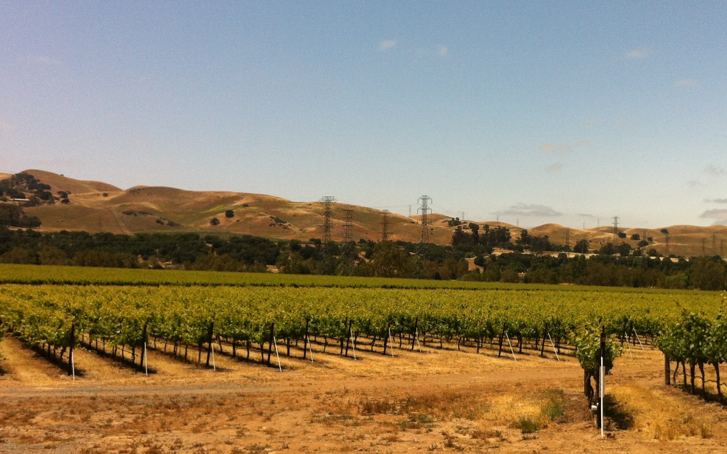
Once back in the San Antonio Valley, we'll continue on the loop by riding north on Mines Road next to The Junction restaurant. This is a long haul along another canyon road with great desert views. Certain sections of this route narrow to a one lane road with rough pavement as mentioned before, so ride carefully. You'll encounter a lot of side roads along the way, but stay on Mines Road until you pull into the Livermore, CA area. Mines Road ends at Tesla Road. Take a left to continue the route. You're only Tesla Road for a short stretch. Look for a left onto Concannon Blvd. to stay on the loop. You can also ride a bit farther on Tesla Road to grab some BBQ at Emil Villa's Hickory Pit. Stay on Concannon Blvd. until it ends at Highway 84, then hang another left to ride south. This four lane road winds through wineries and suburbs to meet up with Interstate 680. You won't get on the Interstate, but rather stay on 84 until you can take a left on Calaveras Road.
The San Antonio Reservoir is on your right as you cruise south on Calaveras Road. You'll enter one more scenic stretch in the foothills called the Sunol Wilderness. If you need a break to stretch your legs, take a detour on Geary Road to past the Sunol Visitor Center down to Little Yosemite on Ohlone Road. This gorge on Alameda Creek features waterfalls and boulders, and it's a worthwhile stop before you head back into the bustling Bay Area. Back on Calaveras Road, there is one more snaking stretch ahead as you continue south past the Calaveras Reservoir. Stay right on Calaveras Road at the junction with Felter Road to ride back into the San Jose outskirts. Watch for a left onto Evans Road which soon becomes Piedmont Road when you hit the city. After you ride by the middle school, the road becomes North White Road. This will take you back down to Quimby Road to complete the loop.
<a href="https://rever.app.link/SuYWXQTFtH" class="btn article-preview__btn w-button">View In App</a>


Take a short but exhilarating ride up and over Patterson Pass on this escape into the hills east of the Bay Area. Interestingly enough, the town of Patterson, CA is a good distance south of this route. Instead Patterson Pass Road connects the communities of Livermore and Tracy, CA. The road over the pass itself is mostly one lane, so proceed cautiously as you ride. Traffic can sometimes get a little bogged down in the narrow sections as vehicles try to pass one another. However, bikes should be able to pass any oncoming traffic with ease even on the one lane sections. Of course, this route is at its best when you hit open stretches of road through the rolling hills. There are some solid food options in downtown Livermore if you want to grab a bite before you ride. Check out Sauced BBQ & Spirits before or after the ride for ribs and live music on the weekends.
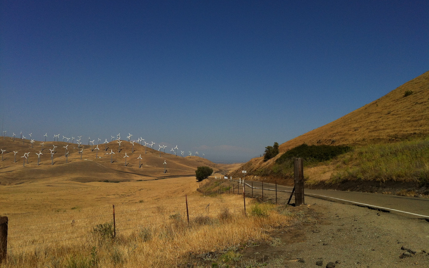
We'll begin the ride in eastern Livermore on Patterson Pass Road just south of Interstate 580. The road starts out with two lanes, but as you ride into the hills, it narrows into a one lane road with just enough room for oncoming traffic to pass. As you leave civilization behind, it's just a short climb up to the pass itself. Once you climb over the hill, you'll be treated to great views of the hills and valley below the pass. There is a little section here where you can pull off and snap some pics. It's hard to miss the large wind farm that lies in the valley below while you take in the view. Continue down from the pass on the steepest section of the route, and then wrap around a hill into a narrow section along a ravine. The terrain flattens as you pass by a large substation. Soon after, the road will widen back into two lanes. You'll meet up with Interstate 580 just outside of Tracy to complete the route.
There are a couple options from here if you want to make a loop of this route. You can either ride up north to Altamont Pass Road or south down to Tesla Road. Both routes will take you through similar terrain in the area. Tesla Road features the Carnegie State Vehicular Recreation Area, so if you're into dirt riding or searching for camping nearby, this is a solid choice. Otherwise turn around and ride Patterson Pass back towards the Bay Area. Watch the steep shoulder with no guard rail on the climb up to the pass from west to east.
<a href="https://rever.app.link/8HgckKRXFU" class="btn article-preview__btn w-button">View In App</a>

"You don't stop riding when you get old, you get old when you stop riding."
― Anonymous


50% Labor Day "Flash Sale"
.jpg)
.jpg)