David Link

Colorado Springs lies an hour south of Denver, CO, and the state's second most populous city is an excellent adventure destination just like Denver. Nestled close to the mountains at an elevation of 6,035 ft., Colorado Springs is a great home base for motorcycle trips in the southern portion of the state. Colorado Springs motorcycle rides offer the ability to explore high altitude vistas and deep pine forests a matter of minutes outside of town. Pikes Peak looms nearby and attracts thousands of race enthusiasts and riders each year, but there is plenty to keep riders occupied in the surrounding area as well. Below are some of our favorite motorcycle rides in Colorado Springs and the southern Front Range of Colorado as selected by the REVER team.
The staff at REVER lives to ride, and we're always pushing the limits to explore new areas of Colorado from our Eagle, CO home base. Below we've picked selected some of favorites from the Colorado Springs area. I've lived in Colorado for over 11 years, and these routes around Colorado Springs are some of my favorites because they're less crowded than many Denver areas. But be aware, some of these routes are more challenging than others. We recommend respecting your limits and doing your homework before attempting any ride.
There is much to see as you head west into the mountains on a Colorado Springs motorcycle ride, and destinations like the Royal Gorge in Canon City, Great Sand Dunes National Park, and more are all within a couple hours drive. You can even cruise right out of the city and into one of the area's best dual sport trail networks in Rampart Range. With so many roads and trails to explore, you need a solid game plan before heading out on motorcycle rides near Colorado Springs. REVER is a great tool to plan and execute the rides you've been dreaming about with ease.
Discovering the best motorcycle rides in Colorado Springs and the surrounding mountains is simple with REVER. Just open the app, gas up and hit the throttle. You can track your ride, share your favorite rides with others, join like-minded communities and more. It's free to sign up, and you can get started immediately. For the best riding experience, REVER Pro members can unlock great additional features to make their rides unforgettable. Get turn by turn directions, discover points of interest and twisty roads, keep your friends and family informed of your location in real time and so much more.
One final note, weather and altitude are a big factor in motorcycle rides near Colorado Springs and shouldn't be overlooked. Be prepared for rapidly changing weather, icy roads in spring and fall, and potential altitude sickness. Rain gear, warm layers and a good supply of water like a hydration system is a must for any ride. Colorado offers some of the best camping in the country, but the choice campsites are miles from civilization, so make sure your motorcycle camp kit is up to snuff before you go. Many routes are closed seasonally, and May to September represents the ideal time to ride most of these roads. After that, many high altitude roads and mountain passes will be closed for the season due to snow and ice. It's wise to check conditions and weather before you set off on any ride in Colorado no matter the time of year.
After a hard day exploring the surrounding area, Colorado Springs has many attractions you won't want to miss. Two geological features highlight the list in The Garden Of The Gods and Pikes Peak. The Garden Of The Gods is worth a quick detour to check out the unique red rock formations in town, but you will want to reserve a good part of the day if you're riding up Pikes Peak or taking the railway. The historic Broadmoor Hotel is worth a visit if you're in the area as well, and you can even have lunch nearby at Restaurant 1858 near Seven Falls. Finally, Colorado Springs features the highest and only mountainside zoo in Cheyenne Mountain Zoo.
While many rides around Denver and the Interstate 70 corridor can be busy and crowded during the summer, Colorado Springs offers a bit of a break in its surrounding mountain areas. This two hour ride near Buena Vista, CO and Salida, CO is perfect for a quick escape. Start by taking Route 24 from Colorado Springs through Lake George, CO until you reach County Road 307. Backtrack east until you link up with County Road 187 and then ultimately County Road 185. The last section of the trail becomes County Road 175 or Ute Trail. It will lead you down to Salida on the north side of town to finish the route. There are plenty of offshoots to explore, and much of this trail is in BLM land, so dispersed camping is allowed. Keep an eye out for fire pits or pull offs that denote quality camping spots.
When you're finished with this ride, you can jet over to Nathrop, CO and head west on county road 162 to check out Saint Elmo, CO. This is one of the best preserved ghost towns in the area. The smaller ghost towns of Vicksburg and Winfield are also nearby. Or you can check out the newly established Brown's Canyon National Monument to try some Gold Medal fishing or simply relax by the Arkansas River. When it comes to local restaurants, both Salida and Buena Vista offer plenty of options. In Salida, grab a slice at Moonlight Pizza or Amicas. If you're heading back north to Buena Vista, grab a burger at the House Rock Kitchen or pizza at the Eddyline Brewery and Taproom.
<a href="https://rever.app.link/fOuFCIJZfU" class="btn article-preview__btn w-button">View In App</a>


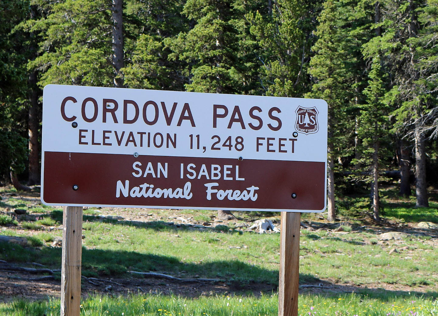
The Cordova Pass route starts a couple hours south of Colorado Springs near La Veta, CO. If you're ready for a memorable detour before this ride starts, continue west on route 160 to visit the tallest sand dunes in North America at the Great Sand Dunes National Park. Late May and early June is a great time to visit the park. In early summer, Medano Creek transforms the snow melt from the nearby Sangre de Cristo mountains into a unique Colorado beach scene. You can also surf down sand tunes for a bit of unconventional but addictive fun. For more information, visit the NPS Great Sand Dunes National Park website.
Now let's return to the Cordova Pass ride. This trail begins off Highway 12 south of La Veta, CO and Cuchara, CO. Turn off the highway and head east on County Road 364 until it turns into 46. Just to the north is West Spanish Peak that towers over the region at 13,626 ft. On the way, you'll ride through Apishapa Arch, which is a tunnel carved through an ancient volcanic rock seam. This tunnel is a great place to stop for a photo opp. Once finished, continue on County Road 46 as East Spanish Peak reveals itself. You'll pass through the tiny town of Gulnare, CO that features a solid lunch spot in the Spanish Peaks Inn dive bar. Finish up this ride by heading north to Aguilar, CO where you can link back up with Interstate 25.
<a href="https://rever.app.link/LU54xDr6fU" class="btn article-preview__btn w-button">View In App</a>


Cochetopa Pass was once the hunting grounds of the Ute Indians and then the site of an old toll road from Gunnison, CO to Sagauche, CO. The pass is easy to navigate in summer and represents a rich area to explore on your bike. Start this route by taking Highway 114 south from Gunnison until you see the pass road on your right. As you ride the trail, San Luis peak looms to the southwest at 14,022 ft. To the east you'll see Cochetopa Dome at 11,132 ft., which is a main feature of the area. The word Cochetopa means “pass of the buffalo” in Ute, and you can imagine this area teeming with buffalo in the past. Pack your camping gear for this ride as there are plenty of primitive camping spots along the route.
Continue along the other side of the pass until you link back up with Highway 114 near Sagauche. If you stop in town, the Oasis offers a solid lunch spot in an otherwise remote area. Or you can head back to Gunnison for pizza at High Alpine Brewing Company or elk burgers at the Ol Miner Steakhouse. For another short two hour plus ride in the area, head down south to Del Norte for the Cross Creek Loop route.
<a href="https://rever.app.link/VKieeBS2fU" class="btn article-preview__btn w-button">View In App</a>


Ride a high altitude route with plenty of twists and turns from South Fork, CO to Del Norte, CO in the Cross Creek Loop. Begin just south of South Fork, CO and turn off Route 160 onto Beaver Creek Road. You'll pass by Beaver Creek Reservoir, and if you're into fishing, rainbow, brook, and brown trout are found here as well as Kokanee salmon. Camping is also available at Beaver Creek Campground. Continue along the Beaver Creek Valley until you turn up southeast to follow the main fork of the creek into higher elevation. Eventually Beaver Creek Road meets Forest Service Road 332, and you'll take a left turn south. For a quick scenic detour, you can continue straight up the road to Poage Lake.
After turning onto Forest Road 332, plenty of twists and turns lie ahead. You'll pass by more fishing opportunities both north and south off the road here where Race Creek runs between Crystal Lakes. When you reach a 4-way intersection, take a left onto County Road 14. Ahead you'll ride a stunning ridge between the west and east forks of Pinos Creek. Look off to the west to see Hogback Mesa at an elevation of 12,247 ft. County Road 14 eventually meets up with Del Norte at the south end of town to complete this loop.
There are several quality food options in Del Norte including Three Barrel Brewing Company and Colorado Grille & Tap House. Del Norte's Grand Avenue is also worth a look as the main street in town still showcases traditional buildings from the 1800s and early 1900s. Still hungry for another ride in the San Luis Valley after lunch? Check out Cochetopa Pass by heading north towards Saguache, CO.
<a href="https://rever.app.link/mOReaPtagU" class="btn article-preview__btn w-button">View In App</a>


Experience almost 4,000 ft. of elevation gain on this easy to traverse gravel road north of Alpine, CO (not to be confused with the Colorado ghost town of the same name). This ride begins along the banks of the Rio Grande River as it runs down through the mountains to Texas and Mexico. The entire Rio Grande headwaters area is an excellent destination for fishing, and Alpine, CO is no different. Start this loop by riding northeast out of Alpine on Highway 15 until you make a slight backtrack left and then north onto County Road 63. Continue along this road until you reach a dramatic climb up a ridge with several steep switchbacks. Once on top, ride the ridge and check out the great views of the area including Pine Cone Knob to the east.
Up next, you'll encounter the loop section of the ride, and stay to the right to continue on the route. As the road curves back around south, it becomes Forest Road 611. The main feature in this area is the interestingly-named Pool Table Mountain. You'll see it off to the northwest, and there are a few rougher jeep trails to explore if you're interested. Stay left at the next fork as you continue south, and after you cross the east fork of Alder Creek, make another left. You'll wind through the forest to link back up with the road you came in on. Turn right to head back down to Alpine.
Alpine doesn't have many services, but South Fork is close by and offers several lunch spots. Ramon's is a solid spot for Mexican, or Two Rivers BBQ is owned and operated by first responders. Test your mettle at Two Rivers by taking the Dementors Challenge. Be warned, you do have to sign a waiver for wings so hot they will “take your soul.” If you survive, head south from South Fork for another route in the area known as the Cross Creek Loop.
<a href="https://rever.app.link/vqb6sCelhU" class="btn article-preview__btn w-button">View In App</a>


Ride along the east fork of the San Juan River and check out a majestic waterfall nearby on this scenic drive up Elwood Pass. The route starts north of Pagosa Springs, CO on Route 160. You'll turn east onto County Road 667 to head towards Elwood Pass. The East Fork Campground is nearby the start of this road. Continue up the rocky trail along the San Juan River. The entire riverbed is a good spot for rainbow and brown trout if you're into fishing. There is also dispersed camping along the river. Several streams link up with the east fork here, but the highlight is Silver Creek Falls about 8 miles in from Route 160. The trail up to the falls is steep but short, and it makes for a great photo spot.
Once finished at the falls, continue riding west along the river. The road gets a little rougher as you continue up towards the pass. The last section of this ride takes you to an elevation of 11,676 ft. Here you are treated to a majestic showcase of nearby mountains. Long Trek Mountain and Montezuma Peak are to the south, and you'll see Lookout Mountain and Cropsy Mountain to the east. You can either turn back down to Pagosa Springs or explore Forest Road 380. Right near the pass is Elwood Cabin, which is a primitive cabin maintained by the Forest Service that you can rent with reservations. If you're headed back to Pagosa Springs, grab a burger at Riff Raff Brewing Company or some cajun food at The Lost Cajun. Treasure Falls is also in the area if you want to visit another popular local waterfall.
<a href="https://rever.app.link/y3HpAOMDhU" class="btn article-preview__btn w-button">View In App</a>


There is plenty to see and do on this engaging ride west of Colorado Springs that starts near the Royal Gorge and heads north through gold mining country. Begin this ride in Canon City, which is home to the Royal Gorge. We recommend skipping the tourist destination and instead heading north on County Road 9 out of town. This route was once an old stagecoach road that is now affectionately called the Shelf Road. It is narrow in parts but represents a great ride for dual sport enthusiasts. This area is also renown for its great rock climbing opportunities. There are two pay camping areas along the road in the Sand Gulch Campground and Bank Campground.
As you traverse the Shelf Road, you'll pass by Red Canyon Park, which is a good spot to pull over and check out the nearby red rock canyons. Continue north through Marigold, CO, which is the site of an old coach stop and ghost town. Eventually you'll arrive at Cripple Creek, CO. This former gold mining town has evolved into a gambling and tourist destination, but the history of the largest gold strike in Colorado is still felt all around the area. Aside from numerous history museums and casinos, Cripple Creek is a great place to stop for lunch. Take a load off and order a burger or wings at Ralf's Break Room, or you can grab a slice at The Cripple Cow. In late August, Cripple Creek is home to the American Veterans Rally & Festival. When you're finished in Cripple Creek, head north on Highway 67 out of town to start a loop around the Cresson Open Pit Gold Mine.
The Cresson Mine is the richest gold mine in Colorado history, and it is still operating today. There is a visitor center nearby if you're interested in learning more about the open pit mining operation. Continue north on Highway 67 until you take a right on County Road 81. To the east, Pikes Peak looms at 14,110 ft., but the smaller peaks of Sheep Mountain and Cow Mountain are visible close by. Continue south along 81 as you see more of the Cresson Mine to the west. You'll arrive in Goldfield and then Victor, CO next. Victor is the sister city of Cripple Creek, and be sure to stop at the Mining Claim 1899 Saloon to try one of their famous burgers. Finish the loop by heading back into Cripple Creek, or take the Phantom Canyon Road south out of Victor to link back up with Canon City. Phantom Canyon was once the spot of a railroad line for the mines, and there are plenty of quality photo ops along the way. Two tunnels and three elevated bridges make this a worthy detour.
<a href="https://rever.app.link/UmNvCdOIhU" class="btn article-preview__btn w-button">View In App</a>


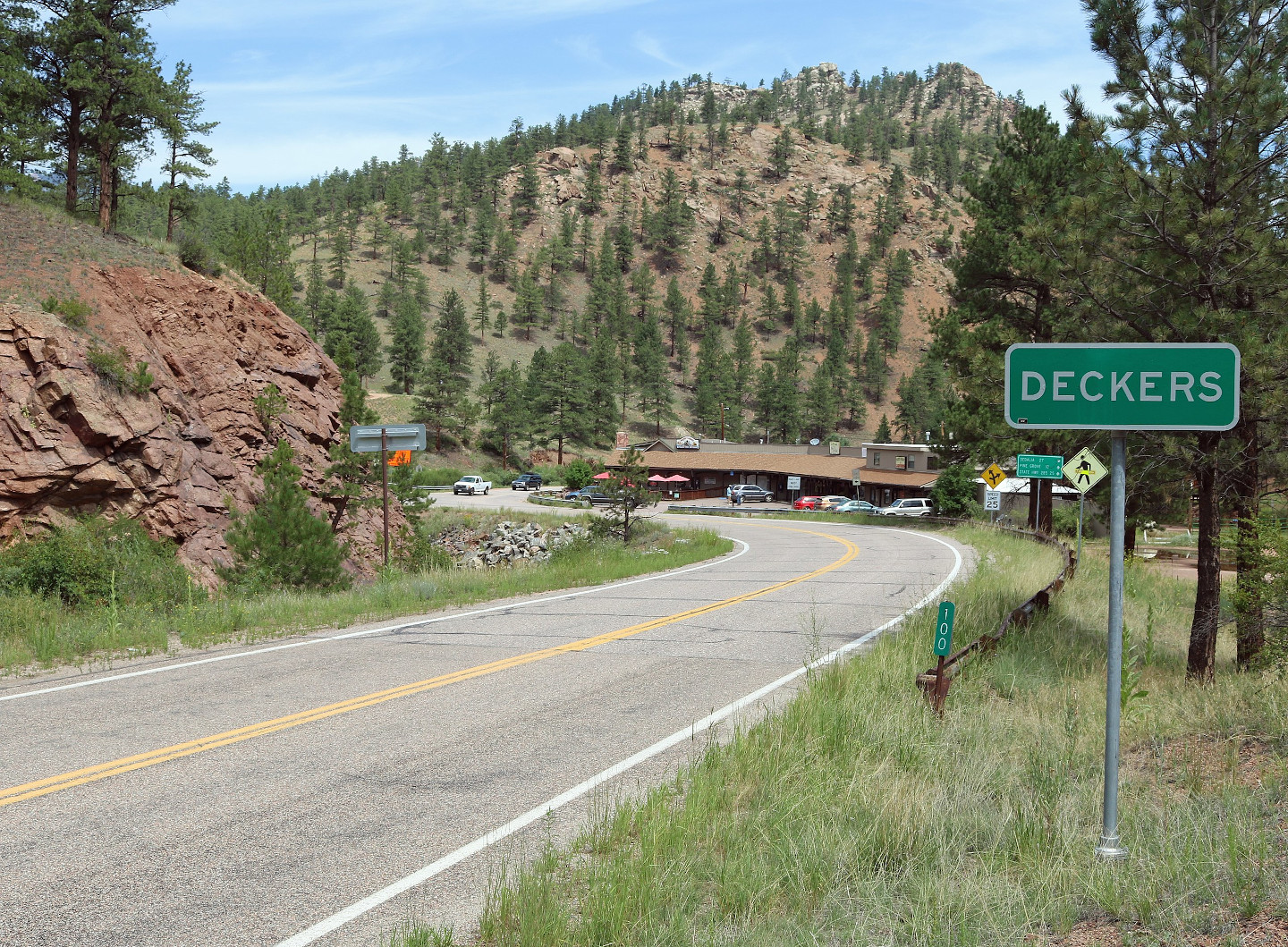
The Goose Creek Road is accessible either from Colorado Springs via Woodland Park, CO or from Denver via Deckers, CO. Once you arrive in Deckers, head west on Deckers Road and take a left on Wigwam Creek Road towards Cheesman Lake. As you ride south, Goose Creek Road will be on your right, but you can also take a short detour down to see Cheesman Lake and ride over the Cheesman Dam. The dam was once the highest in the world at 211 ft. tall. It was first constructed in 1905 to provide water for the growing Front Range area by famous water engineer Walter Cheesman.
Now let's get back to Goose Creek Road. Continue south along the route and to the site of one of Colorado's largest forest fires, the Hayman fire. This area is still recovering, which makes for unique, sometimes eerie scenery. Next, you'll pass by the interesting rock formation known as Sheeprock. This climbing destination is worth a stop for photos. The terrain makes for an engaging ride in this area as you'll encounter winding switchbacks down into wooded draws. Soon after Sheeprock, you'll pass over Goose Creek, which is also the site of the Goose Creek Campground. Goose Creek Road actually becomes Matukat Road as you cross into Park County. The final section of this road is a thrilling ride you won't want to miss. You'll thread between massive granite peaks and down into the valley to link up with Highway 77.
You can turn this ride into a loop by heading south on 77 and then east on Route 24 at Lake George, CO. Once you reach Woodland Park, CO, take Rampart Range Road back to Deckers. This road cuts through a dual sport and ATV paradise with plenty of side roads and trails to explore. No ride in this area is complete without a visit to the famous Bucksnort Saloon. From Deckers, head north on Highway 126 through Buffalo Creek, CO to Pine, CO. Turn right at Pine, and then take Elk Creek Road north until you encounter the Bucksnort hidden in the valley.
<a href="https://rever.app.link/4KIaXHq6iU" class="btn article-preview__btn w-button">View In App</a>


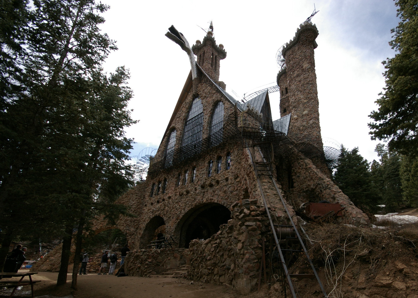
Explore the Pueblo, CO area and ride to the top of Greenhorn Mountain in this route south of Colorado Springs. This ride starts in Fairview, CO just north of the oddity known as Bishop Castle. The castle has been hand-built stone by stone by local resident Jim Bishop, and it features three stories that reach to a height of 160 feet. For the Greenhorn Mountain ride, begin at Ophir Creek road, also known as Forest Road 360, which is near Ophir Creek Campground. When you reach a 4-way intersection, turn left onto Forest Road 369 to reach the Greenhorn Mountain wilderness. As you ride, enjoy the remote area and keep an eye out for dispersed camping. You'll encounter two crystal blue lakes as you ride towards the summit. The main road ends just below the peak of Greenhorn Mountain at 12,347 ft.
<a href="https://rever.app.link/tobVqAF6iU" class="btn article-preview__btn w-button">View In App</a>


Challenge yourself on a rocky and narrow dual sport trail with this scenic ride over the Continental Divide. This route begins west of Nathrop, CO and Salida, CO near two ghost towns. Alpine and St. Elmo were both mining towns from the mid 1800s. A few residents still live here, and they have fixed up the abandoned buildings back to their former 1800s style. St. Elmo is especially worth pulling over for a photo opp. South of St. Elmo, take County Road 295 to begin this ride. You'll follow Chalk Creek, which features several quality fishing spots. As you ride towards the Continental Divide, you'll pass by more historical sites including the Hancock ghost town and the site of the Alpine Tunnel. At one point, the Alpine Tunnel provided railroad service between Denver and Gunnison. Although no longer in service, it remains the highest railroad tunnel in the world. Today the tunnel is sealed for safety reasons, although it is still a popular hiking spot in the area.
Once you've crossed the Continental Divide, gear up for another mountain pass as you ride through a high alpine valley to Tomichi Pass. Below the pass is another ghost town, White Pine, and it has been mostly deserted since the 1900s due to a history of frequent avalanches. Snowblind Campground is nearby and named for the snowy area. Take a left at the fork in the road on County Road 888, and then soon after take another left onto County Road 237. You'll be treated to an engaging road with many switchbacks down until you pass by the Monarch Ski Area. Link up with Highway 50 to end this route. Head back east on Highway 50 to Salida, CO to grab a bite at Currents downtown along the river.
<a href="https://rever.app.link/NgaRjlvmjU" class="btn article-preview__btn w-button">View In App</a>


Tackle a moderately-difficult pass through the Sangre de Cristo Mountains in this short one hour point to point ride. Access Hayden Pass by heading south west from Colorado Springs to Canon City and then Cotopaxi, CO. You can either start at Coaldale, CO and take Hayden Pass heading west, or start at Villa Grove, CO and head east on the pass. This is a rocky and sometimes difficult to traverse trail. The west to east route from Villa Grove is the more challenging of the two. Hayden Pass is officially marked as County Road 6 on the map. The area south of Villa Grove is home to the Orient Mine and Valley View Hot Springs. In the summer months, you can view the local migratory colony of 250,000 bats leave the Orient Mine each night to feed on insects.
Once you're done riding the pass, Salida and Canon City offer great lunch spots on the east side. The Whitewater Bar & Grill in Canon City is definitely worth a stop to check out their epic patio. In addition to a solid menu, the patio offers axe throwing, cornhole, fire pits and sand volleyball. If you decide to ride Hayden Pass east to west, you can easily link up with another nearby ride in the Cochetopa Pass route that takes about an hour and a half to complete.
<a href="https://rever.app.link/yFDMx2bnjU" class="btn article-preview__btn w-button">View In App</a>


"You don't stop riding when you get old, you get old when you stop riding."
― Anonymous


50% Labor Day "Flash Sale"
.jpg)
.jpg)
.jpg)
.jpg)
_far_s-w_rio_grande_co,_co_-01_(9601004808).jpg)
.jpg)
_far_s-w_rio_grande_co,_co_-04_(9598211963).jpg)
_3.jpg)
_10_(49172216806).jpg)
%E2%80%943.JPG)