David Link

Denver, Colorado, the Mile High City, is without a doubt one of the best places in the country to plan an epic motorcycle ride. Denver motorcycle rides offer the ability to quickly escape the city to see towering peaks and ride exciting mountain roads, but you can be back in time to catch a Rockies baseball game or quench your thirst at one of Denver's world-class breweries. Nestled just east of the Front Range of the Rocky Mountains, Denver is an excellent jumping off point for both quick afternoon rides and longer tours of the state's unforgettable geography. The nearby town of Boulder close to Denver has even been named the happiest place to live in America.
REVER is based out of Eagle, CO, and our weekends are spent exploring the best roads around Colorado. These routes represent some of our favorites in the Denver area. I've lived in Denver over 11 years, and I can attest these are some of my favorite areas. Remember if this is your first time in Colorado, the ideal riding season runs late April / early May through September. Some roads, especially mountain passes, are closed during the winter months. Many of the Denver routes listed below are paved and represent great options for those looking to gain experience in mountain environments. However, we always recommend you respect your limits and do your homework before trying any route.
There are thousands of miles of winding mountain roads in Colorado, and it pays to carefully plan your route before you fire up your bike and head out. REVER makes it easy to uncover the best Denver motorcycle routes for both locals and visitors alike, and it's free to get started. You can discover established routes recommended by our staff, join communities of like-minded riders and create your own routes to share with others. REVER will never share or sell your information with anyone else, so you know your trips and location stay 100% private unless you decide to share it with others. Before you hit the road, check out Five Simple Tips To Get The Most Out Of REVER to get the most out of your trip.
Better yet, you can experience the best each Denver motorcycle ride has to offer by joining as a REVER Pro member. You'll get access to features like LiveRIDE that sends SMS Alerts to friends and family and allows them to track your location in real time. You can use turn-by-turn and voice navigation as you ride as well as receive recommendations for points of interest along the way. If you're worried about losing service, REVER Pro offers the ability to download maps. For a full list of perks, check out REVER Pro.
As you plan motorcycle rides near Denver, remember that the weather can change rapidly in the Rocky Mountains. It's not uncommon for clear, sunny skies to turn to pouring rain in a matter of minutes. Invest in quality rain gear to stow away for those crazy weather days. Riders should also be aware of altitude sickness when riding at higher elevations. Make sure to stay hydrated and eat plenty of carbohydrates to lessen symptoms. Consider a hydration pack to ensure you have enough fluids for the entire ride. Come prepared with water, energy snacks, rain gear and warm riding clothing, but don't let the weather or altitude deter you from truly memorable motorcycle rides in Denver and the surrounding Front Range. Make a weekend of it and experience some of the best camping in the nation by packing lightweight motorcycle camping gear. Don't forget to pair your sleeping bag with sleeping pads to stay off the cold ground. It will help you get some quality sleep, because nothing beats waking up in the morning well-rested and surrounded by mountains.
When you finish up a motorcycle ride in Denver, there are several attractions nearby to explore. Start with buffalo or elk steaks at Denver's oldest restaurant, the Buckhorn Exchange. Founded in 1893, this historic spot was a favorite hangout of Buffalo Bill. You can also ride up to visit his grave in Golden, CO. There are a wealth of museums to visit in the area as well as the Denver Mint that still produces coins for US circulation. Denver also boasts a rich professional sports community, and it's never a bad idea to catch a Broncos, Avalanche, Rockies, Nuggets or Rapids game when they're in town.
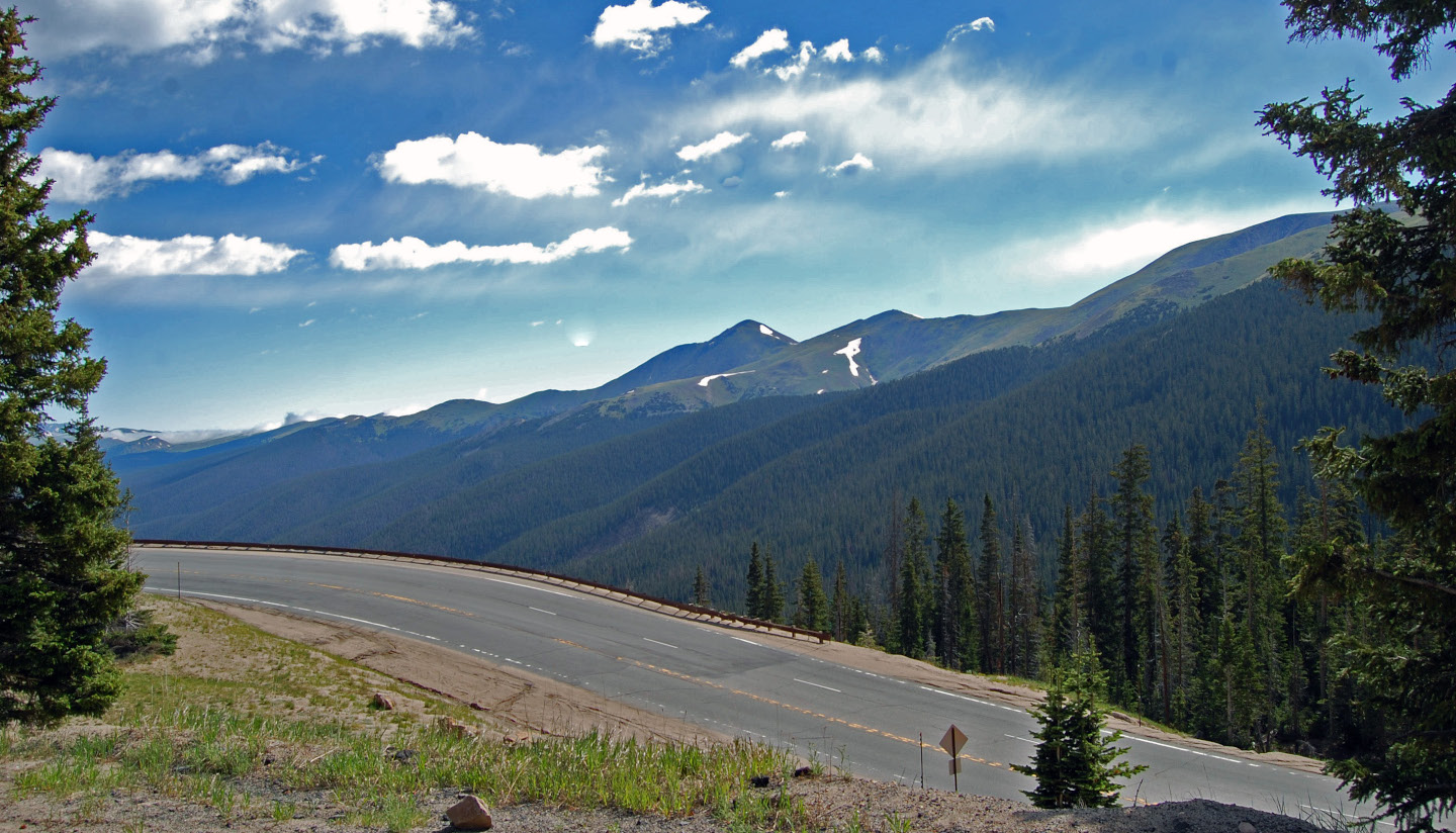
Explore the site of Colorado's first gold rush and ride to the top of the highest paved road in North America with this easy to access route just west of Denver. The ride starts in Golden, CO, which is named for its role in the first Colorado gold rush. It is also home to the largest single-site brewery in the world, Miller Coors. Just outside of town, you'll wind up Clear Creek Canyon on Route 6, and there are plenty of pull offs to take in the rushing water or try your hand at some gold panning or fly fishing. After a quick jaunt on Interstate 70, take Squaw Pass Road to approach one of the iconic 14,000 ft. peaks, or 14ers, in the Front Range.
At the heart of this loop is Mount Evans, and it rises to a staggering 14,130 ft. above sea level. The road leading to the summit is the highest paved road in North America, and it offers astonishing views of granite peaks, alpine lakes, bristlecone pines and even the occasional mountain goat. Between the winding switchbacks and the lack of guardrails, there is plenty to keep your heart pumping on the way to the summit. (Note: Mt. Evans is only open Memorial Day to Labor Day each summer. We recommend checking current conditions and closures before riding. If Mt. Evans is closed, you can continue down to Idaho Springs, CO on the route.) As you descend back down Mt. Evans road, the Echo Lake Lodge is a great lunch spot with rustic food like buffalo chili. Or Idaho Springs offers great hole in the wall BBQ at Smokin' Yard's BBQ and buffalo burgers at the classic-themed saloon known as The Buffalo Bar.
Finish up this Denver motorcycle route with a trip to Central City and Blackhawk. These two historic gold rush towns from the 1800's are now popular casino destinations near Denver. For an interesting distraction, be sure to stop by the Teller House Bar in Central City to see the Face on the Barroom Floor. After leaving Blackhawk, head north to link up with Highway 46, and then ride through Golden Gate Canyon State Park to catch more scenic mountain vistas. You'll complete the loop by arriving right back in Golden at the north end of town.
<a href="https://rever.app.link/e67sy8bGtH" class="btn article-preview__btn w-button">View In App</a>


Two rugged 11,000 ft. passes highlight this trip through the heart of Colorado ski country. Start in Empire, home of the original Hard Rock Cafe (think miners, not rock 'n roll), and then proceed up winding roads and switchbacks to Berthoud Pass. At the top of the pass is a visitors center if you want to stretch your legs and take in the snowy peaks. Watch for icy conditions in the early spring and late fall. Down the other side of the pass is the first ski town on this loop, Winter Park, CO. Once on the strip, be sure to stop by Fraser Valley Hot Dog for some Chicago-style hot dogs and unique sausages. Continue north through Fraser and Granby, and consider a quick detour to Lake Granby, one of the largest lakes in Colorado.
Next, turn back south for the second half of the loop through Hot Sulfur Springs, CO. If you're into hot springs, this is a great town to stop for a dip in 23 different pools of varying heat. Continue on to another town in the heart of ski country, Silverthorne, CO. Make a stop in Keystone at the GOAT Soup and Whiskey Tavern for a unique menu and live music. Finally, instead of driving up to the Eisenhower Tunnel and back to Empire, take Loveland Pass at an elevation of 11,990 feet for a scenic ride near some of the Front Range's iconic 14ers. This route is open even in the winter as large trucks and hazardous loads have to take it instead of using the Eisenhower tunnel. You'll see more popular ski areas including Loveland and Arapahoe Basin to finish up this loop, and the Loveland Pass parking lot offers high altitude hiking trails. To complete this loop, jump back on I-70 east towards Denver.
<a href="https://rever.app.link/iim1OjcGtH" class="btn article-preview__btn w-button">View In App</a>


Ride some of the best scenery Colorado has to offer in this loop that takes you through Rocky Mountain National Park, up to Walden, CO and then along the banks of the Cache La Poudre River. This route starts in Lyons north of Boulder and winds up to one of the most popular mountain towns in Colorado, Estes Park. Once in Estes Park, stop by the Stanley Hotel to visit the historic location that inspired Stephen King's The Shining and was featured in Dumb And Dumber. If you're hungry, visit the historic Rock Inn Mountain Tavern or grab some BBQ at Smokin' Dave's. There are no restaurants in Rocky Mountain National Park, so you'll have to wait until you get to Grand Lake if you get hungry on the way.
Next up is a ride through Rocky Mountain National Park. Proceed through the main park entrance and up to Trail Ridge Road. (Note a park entrance fee is required for this ride. This route is seasonal, and Trail Ridge Road is closed each winter. Be sure to check conditions and road closures before heading out. Also watch for wildlife like elk and big horn sheep along the road. Visit the NPS Rocky Mountain National Park website for more information.) If you prefer a slower ascent on a gravel road, take a detour on Old Fall River Road that meets back up with Trail Ridge Road. Old Fall River Road first opened in 1920, and today it is a one way up the mountain, but fair warning, you will encounter plenty of slow moving tourists in the summer. Once at the top, stop by the Alpine Visitors Center to stretch your legs and maybe spy a herd of elk in the valley below.
Marvel at the unforgettable scenery above the tree line here, and then continue down the western side of Rocky Mountain National Park into Grand Lake. Grab some eats at Sagebrush BBQ known for their cow skin tablecloths. Next, take a short jaunt down to Granby, CO and then head north on 126 to Walden. Then head east on Highway 14 into State Forest State Park and into moose country. Be sure to stop by the Moose Visitors Center to hopefully catch one of these illusive creatures at the edge of the forest. Finish up this ride by following the Cache La Poudre River, and stop to throw in a line if you're into fly fishing. Rainbow, brown and brookies are all common here. Finally, cruise back down into Lyons, CO along the foothills to wrap up this loop.
<a href="https://rever.app.link/3HN7jUdGtH" class="btn article-preview__btn w-button">View In App</a>


This short one and a half hour loop takes you through two big Colorado ski areas and up to the highest incorporated city in the US. After a trip up Interstate 70 from Denver, exit at Copper Mountain. For an extra thrill before you travel south, check out one of North America's longest alpine coasters in the Rocky Mountain Coaster. Head through rugged mining country on Highway 91 until you arrive at Leadville, CO, also known as the Two Mile High City. At 10,152 feet, this is the highest incorporated city in America. Be sure to watch for icy conditions on the way in the spring and fall. While there, check out the Silver Dollar Saloon founded in 1879. Doc Holiday often frequented this drinking establishment when he lived in Leadville shortly after the gunfight at the O.K. Corral.
Leaving Leadville, turn back up north on 24 and ride more beautiful country until you link back up the Interstate 70. Finish this loop by driving over Vail pass back towards Denver. At 10,666 ft., Vail pass can become dangerous in early spring and late fall. The pass may even be closed at times due to bad weather, so make sure to check conditions before heading out.
<a href="https://rever.app.link/jdrbDWdGtH" class="btn article-preview__btn w-button">View In App</a>


Climb the second-highest paved road in the US, ride through the breathtaking Glenwood Canyon, and cruise up to the highest town in America in this high altitude tour a few hours outside of Denver. This route starts at the beginning of Independence Pass that rises to 12,095 ft. above sea level. As with any high mountain pass in Colorado, be sure to check weather conditions before you ride and be aware of lightning. Also note, the pass is closed during winter. As you ascend Independence Pass, stop for views to the east of Mount Elbert, Colorado's highest peak at 14,440 ft. and the second-highest peak in the continental US.
Head west into Aspen to explore the silver mining town turned tourist destination. Though often popularized as a destination for the rich, Aspen is full of culture and was once home to writer Hunter S. Thompson (who unsuccessfully ran for Sheriff there) and singer John Denver. Make sure to stop by the Hickory House cabin for some good BBQ. Continue on up Highway 82 through Carbondale, which is a good backup plan for lunch if Aspen is too crowded for your liking.
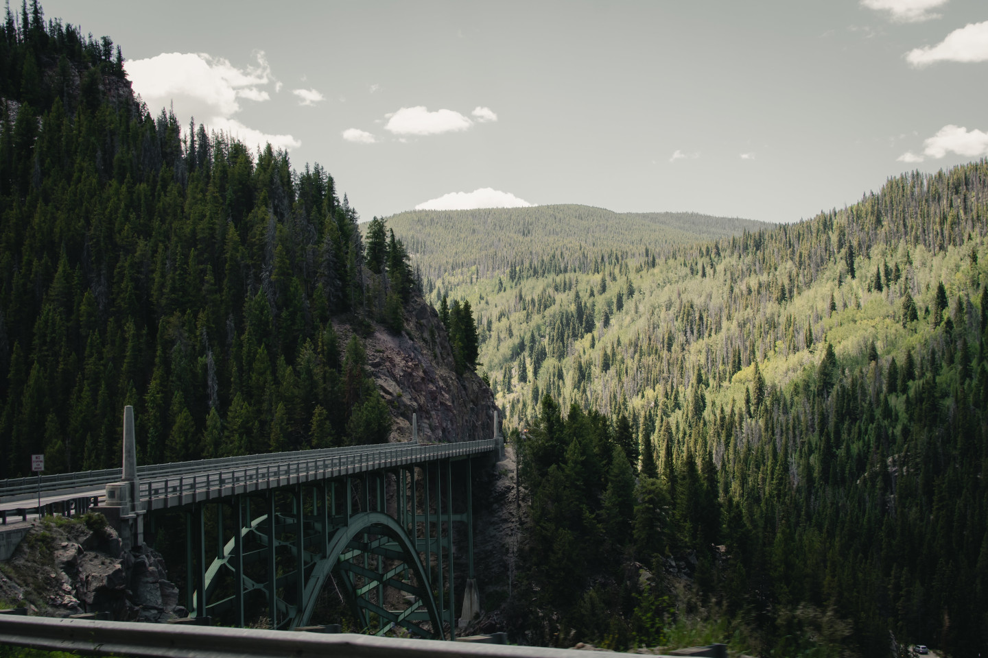
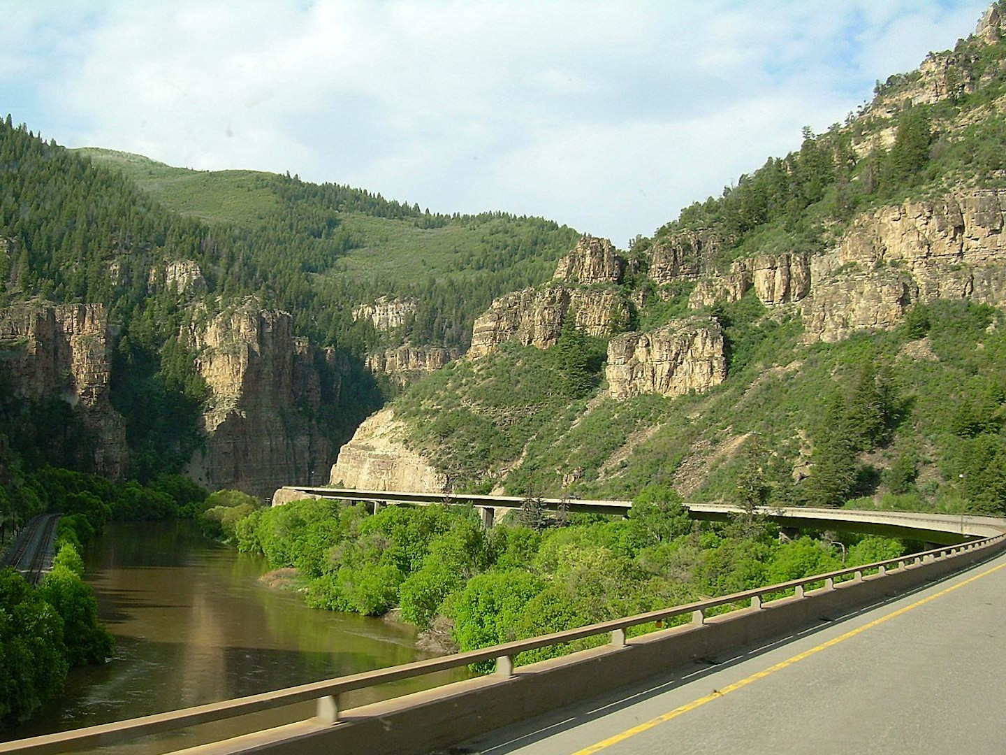
Next up is Glenwood Canyon, one of the most spectacular sights of Colorado. This canyon is formed by the upper Colorado River and features towering walls as high as 1,300 ft. Stop to stretch your legs at one of the many pull offs along the canyon, or take a detour up to the famous Hanging Lake (reservations now required in advance). The town of Glenwood itself is worth a stop for a bite to eat or a dip in hot springs as well. As you continue east along I-70, you'll pass by REVER's home base in Eagle, CO. Finish off this epic route by taking Highway 24 through Leadville, the highest incorporated town in the US. To complete the loop you'll arrive back at Twin Lakes and the start of Independence Pass.
<a href="https://rever.app.link/pP5KjXdGtH" class="btn article-preview__btn w-button">View In App</a>


This loop starts at the highest city in the US, Leadville, CO, and then it proceeds up the highest open mountain pass in the US. Head east on County Road 3 from Leadville to start Mosquito Pass. This dual sport route is not for the fainthearted, and when it was first established in the 1800s, it quickly earned the nickname “the highway of frozen death.” The 13,208 ft. pass is snowed over and frozen most of the year, and it's not open until the later summer months like August. Be sure to check conditions and be aware of storms that can bring dangerous lighting. Much of this road is above the treeline, and you won't be able to quickly retreat if a storm threatens. However it is well worth braving this road if you have the right setup. You can explore remote Colorado high country few others ever see and cross the Continental Divide on your way to Alma.
Bonus Tip - If you decide to take Mosquito pass one way and head back to Denver on 285, turn south on Elk Creek Road towards Sphinx Park to discover one of Colorado's best hidden restaurants and biker bars in the Bucksnort Saloon.
<a href="https://rever.app.link/8hxsDIsNtH" class="btn article-preview__btn w-button">View In App</a>


Avoid the busy traffic along I-70 and instead head down Highway 285 for this loop through some remote country southwest of Denver. This ride starts in Morrison, CO near the world famous Red Rocks Amphitheater. You can visit the park for free anytime there isn't a concert scheduled. Out of Morrison, link up with 285 for an easy highway ride through the foothills and up into the mountains. As we mentioned in the Mosquito Pass route, the Bucksnort Saloon near this route is definitely worth a detour if you've never been. Take Elk Creek Road through the valley to find this gem in the middle of nowhere.
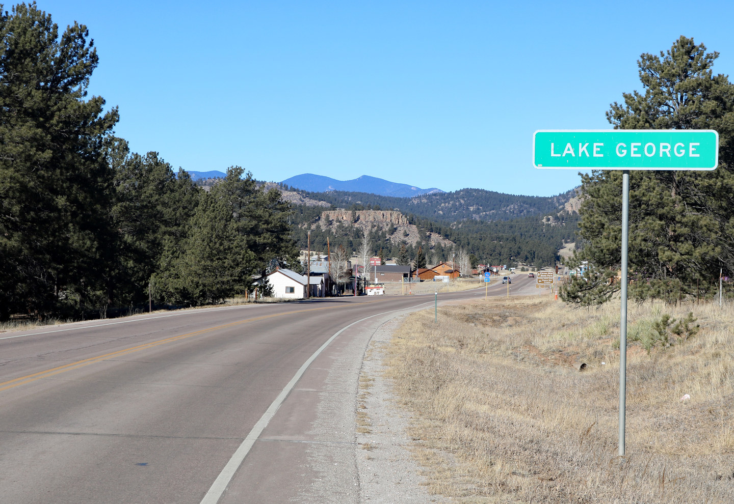
Once you arrive in Bailey, consider a stop at Mad Jack's Mountain Brewery for a little mountain town flavor. Then continue back on 285 until you reach Jefferson, CO where you'll head south on Highway 77. Stop at Eleven Mile State Park near Lake George, CO for some hiking or fishing, or check out the Thunderbird Inn in Florissant, CO for a divey roadside bite. The Florissant area is also famous for its large collection of insect and plant fossils. Then head back east to Woodland Park, CO where you'll turn on Highway 67 for another solid ride back up to Highway 285.
<a href="https://rever.app.link/oEaXXHOnjZ" class="btn article-preview__btn w-button">View In App</a>


Ride by one of the steepest canyons in America and explore high desert country in Colorado with this epic journey that starts a few hours from Denver. This route can be accessed either via Highway 285 to Highway 50 via Denver or from Grand Junction, CO. Start in the Uncompahgre Valley in the city of Montrose, CO and head east towards Sapinero, CO on the south side of the Gunnison River. Montrose is also home to the <a href=”https://www.facebook.com/westerncovintage/”>Unknown Motorcycle Show</a> in early June. If you want to visit the south rim of the Black Canyon of the Gunnison, you'll want to take 347 north near Montrose. We'll get into more details about the park shortly. Before you arrive in Sapinero, you'll see the Blue Mesa Reservoir, which is the largest lake in Colorado. This is a great place to throw out a line if you're into fishing, or you can stop for a bite at Pappy's Restaurant overlooking the lake.
Next, turn back west on 92 and drive over the Blue Mesa Dam. This is where the best part of the ride begins. Hug the edge of the Gunnison River and drive an engaging, winding highway along the rim towards the north side of the national park. Be sure to hit some of the pull offs for epic views in this section. Once you get to Crawford, you can turn back south to visit the north rim of the Black Canyon of the Gunnison or continue on to Hotchkiss, CO.
This part of the ride outside the park is worth the trip alone, but for the best views of the deepest section, you'll need to enter the Black Canyon of the Gunnison National Park. This represents a bit of a detour from our listed route, but you won't regret the visit. The canyon is so steep it only receives 30 minutes of sunshine per day in certain areas, which is where the namesake “Black Canyon” originates. Be sure to take in the rugged canyon from both the visitors center and roads along the rim. (Note there are seasonal closures for this park, and some roads are closed during winter. Visit the NPS Black Canyon Of The Gunnison website for more information).
Moving on from the spectacular canyon, Hotchkiss, CO is next up on this route. Check out Zach's BBQ or Pat's Bar and Grill for some quality small town eats. Make your way west to Delta, CO next, or stop along the way for some fishing. The entire Gunnison River area is well known for its trout fishing. Finally, finish up the trip by heading back south on Route 50 to Montrose to complete the loop.
<a href="https://rever.app.link/UDGeYveGtH" class="btn article-preview__btn w-button">View In App</a>


While this route begins several hours away from Denver, it is still easy to access via a 4 hour drive on Interstate 70 as long as the conditions are good. The loop itself is over 5 hours, so you may want to make a weekend trip out of this and secure lodging in Grand Junction, CO the night before. Our partner site The Dyrt is a great resource for camping recommendations. As a bonus, REVER Pro Members receive extra discounts on a Dyrt Pro Membership.
You'll start this ride in Grand Junction in an area locals call the Western Slope. This area is highlighted by the rushing waters of the Colorado River as it makes its way through Utah to the Grand Canyon. It is also home to the Vulcan Riders Rocky Mountain Stampede in late July if you're a Kawasaki rider. Start by heading back east through Palisade, CO towards Mesa. You'll be riding through Colorado wine and orchard country, and there are plenty of tasting rooms to visit. Once you arrive in Mesa, CO, head south on 65 towards the Grand Mesa.
The Grand Mesa is the largest flat-topped mountain in the world and covers nearly 500 square miles. There are over 300 lakes in this geologically unique area, and it is a fly fisherman's paradise in the summer. Continue on from the Grand Mesa through the towns of Orchard City, Hotchkiss and Paonia. If you're a BMW enthusiast and planning a trip in mid July, be sure to stop by the Top O' The Rockies Rally in Paonia, CO. Moving on, you'll reach the outskirts of Marble, CO. You can continue north on the route or take a short detour into town. Marble is famous for its quarry that has produced some of the best marble in the world used in the Tomb of the Unknowns and the Lincoln Memorial in Washington D.C. For some excellent BBQ, make sure to stop at Slow Groovin' BBQ for some great eats.
The final part of this loop proceeds north through Colorado and back west towards Grand Junction. Not to be overlooked, you'll link up with I-70 at the spectacular Glenwood Canyon. Make sure to hit one of the several pull offs to take in the natural beauty. Glenwood Springs, CO is also known for the world's largest mineral hot springs. Next up on I-70 is Rifle, CO with some great natural wonders nearby like Rifle Falls and the Rifle Arch Trail that features a 60 ft. high 150 ft. wide natural sandstone arch. Proceed back down I-70 along the Colorado river to finish this loop.
<a href="https://rever.app.link/a1C6nyeGtH" class="btn article-preview__btn w-button">View In App</a>


"You don't stop riding when you get old, you get old when you stop riding."
― Anonymous


50% Labor Day "Flash Sale"
.jpg)
.jpg)
.jpg)