


At REVER we set out to create the most-intuitive, easy-to-plan-on route-mapping tool possible. Over the last five years, we’ve worked to constantly improve the interface, add new features, and provide content and tools, to give our users the best experience possible. In our support channels, we get lots of feedback about the planner, and have tried to apply that information to our development process. In an effort to ensure our users are getting the most out of the system, we’ve put together a list of tips and tricks to make your planning experience as slick as possible.
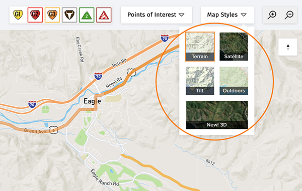
5. Utilizing Map Styles
Our online planning tool has multiple map styles to help you plan the perfect route. Choices include: Terrain, Satellite, Tilt, Outdoors and now 3D (see below!). Our base map defaults to the Terrain view, which shows a detailed view of roads, highways, lakes, rivers, parks, etc. Very similar, but with a few added features is the Outdoor view; which additionally includes topographic information such as elevation reference with numerical markers. The latter is fantastic for planning ADV, and off-road rides. The Tilt map allows you to see a rider’s-eye perspective of the terrain you’ll be riding through.
Satellite is perhaps the most useful tool for off-road/dual-sport riders and ADV riders. Not every trail or jeep road is considered a navigable road by our mapping software, but that doesn’t mean you can’t plan on them. You can plan a route where there are no roads or unmarked roads by utilizing the Polyline Tool (See tip number 6 below), and planning in Satellite mode. Even though our base map doesn’t have a road or trail many of these are still visible in Satellite.
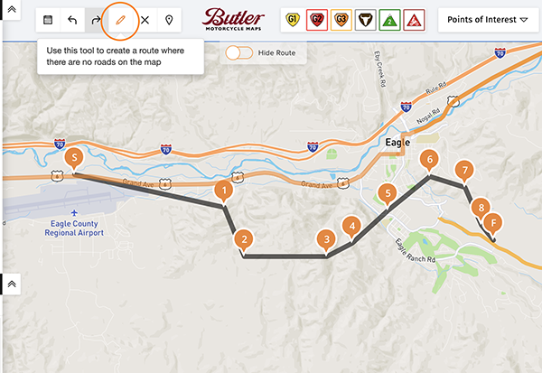
6. Polyline Tool
As mentioned above, sometimes you want to plan a route where there are no roads (think dry lake, sand dunes, meadow), or where there are no formal indicators on the map of a trail/road, even though you can see it in Satellite view. Or sometimes the mapping software has picked up bad open-source information and thinks a road is one way where it’s not, or has another issue. You can switch over to the Polyline Tool (the little pencil in the toolbar) and get past that problem area, then go back to the normal planning tool (which snaps to road) by clicking the Polyline Tool again when finished.
The Polyline Tool lays down straight lines and will not snap to a road’s contours. So you need to take smaller bites. Tip to save waypoints: Unless you are planning over an area that has lots of forks in the road/trail, don’t be afraid to cut corners; when you ride the route, just stay on the main route. A general rule of thumb is to use as few waypoints as you can when planning, so don’t get hung up trying to trace the contours of a trail perfectly.
7. Manually Drag Waypoints to Modify Ride
If you’ve planned a ride or are in the process of planning a ride and want to alter a waypoint to add a detour midway through the route, or just need to clean up where a waypoint was placed, you can grab that point and move it, instead of undoing all the points after it. Or you can drag the route line itself and drag it to where you want it, to alter the route. It will automatically add a waypoint for you. Just know, that if it’s a very dramatic change it might slightly alter the route that follows. If you want that added waypoint to be a very specific address, you can go into the address boxes after you’ve moved it and put in a specific address or GPS coordinate.
8. Moving Your End Point Instead of Adding Waypoints
REVER’s turn-by-turn navigation engine is limited to 25 waypoints by our mapping provider. You’d be amazed at how detailed a route you can build with that many waypoints. But sometimes on very long or complicated routes, you may seemingly need more. But learning to be thrifty with waypoints can in many cases help you stay under that threshold. (Note, there aren’t waypoint limitations to rides on which you intend to navigate following the blue route line). An easy trick to avoid using too many waypoints, is to carefully move the last waypoint along the route by dragging it, instead of placing new waypoints afterwards. But be careful, if you take too big of bites it can alter your intended route. For example, you are planning along a frontage road and it thinks the highway is more logical; in this case you may have to grab the middle of that last route-line section and drag it back onto the intended route (therefore adding a waypoint). If you have too many waypoints, another trick is to zoom out to where you can see most of the route, then go to the waypoints icon in the toolbar and select it. Try eliminating a few waypoints, by Xing them out. Sometimes it will alter the route, but many times, it will follow your intended route based on the information before and after that waypoint. You can always undo the change if it doesn’t work.
9. Plan in 3D!
The world isn’t flat! Even the ancient Greeks figured that out in the sixth-century BC. But unfortunately, maps have been 2D for thousands of years. Planning on a flat map is great for tactical and directional simplicity, but what if you want to know what the elevation looks like where you want to ride? Well, now you can with REVER’s brand-new 3D-online planner. It’s super easy to click along a map and see where the route goes, but missing, is the elevation that the route undulates over. Our suggestion is to either look at an area you want to ride and preview it in 3D and then go back and plan in a traditional mode (Terrain, Outdoors), and then after you have planned it, switch back to 3D and see what the completed route looks like. If you are planning in Kansas, this may not be as impactful as if you were planning in the Colorado Rockies, the Alps, or California’s Sierra. But give it a go, and see if this PRO feature is a useful tool to help make your planning experience better.
.avif)